om·ni·pres·ent
adjective \-zənt\
: present in all places at all times
This definition of omnipresent sums up many facets of society. Fast food chains? Everywhere. Reality TV shows? You know the answer. And what about Google? Yup, right again.
What started as a simple search engine back in 1998 is now an omnipresent force, spanning search, email, video, productivity, smartphones, laptops, glasses, navigation and more. And by more, we mean more. Just last month, Google acquired Nest for multiple billions, even though it really only has a (smart) thermostat and smoke detector to its name. But it’s all about the future, and the future is very much about smart homes and the Internet of everything.
Not long before Nest, Google acquired Boston Dynamics, a company that builds robots that can walk and run and have names like BigDog, Cheetah, WildCat and Atlas. Cheetah can apparently run faster than Usain Bolt. This initiative could well be bolstered by its subsequent acquisition of artificial intelligence (AI) firm DeepMind, for what’s thought to be in the region of $500m.
Five years from now, Google may have data-points from every facet of your life – at home, on the bus, and in the car. However, this is all just scene-setting for what we’re really here to talk about – maps.
Navigation: There’s a (Google) map for that

Deeply entrenched in Google’s arsenal of innovation is Google Maps, a service you’ve no doubt encountered in your time online through Google’s own cross-platform mapping tools, or the slew of third-party apps that suckle from its navigational teat. Maps is a massively useful service, one that single-handedly underscores the value of 3G- and 4G-enabled smart devices, as it means no more expensive satnav systems for your car, and no more stopping strangers in the street to ask where the Horse & Hound pub is.
As with most of Google’s services, Maps brings endless value to the table, and it’s difficult to knock something that has ultimately changed the way people interact with the world around them. But is a future where Google knows where you are at all times a good thing?
We’re already seeing how Google+ is being used as its cross-product glue, providing a ‘unified’ experience. Want to post a comment on YouTube or write a review on Google Play? You gotta use Google+. Google Maps is one obvious omission here – you can use it on the Web without having to surrender any account details. Could that change in the future? Who knows. But anything’s possible.
Of course, you’re not physically tethered to Google Maps – you use it because it’s genuinely a great service. Decent alternatives include Microsoft’s Bing Maps and Nokia’s HERE mapping services, but ‘Google Maps is Google Maps’, right?
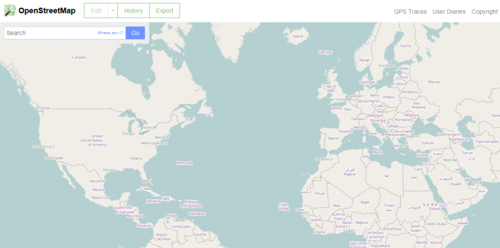
Then there’s OpenStreetMap, which you may have encountered before without really knowing it. For the unitiated, OpenStreetMap is a free, editable map of the world created by the online masses. Yes, it’s just like Wikipedia…but for maps.
OpenStreetMap is also a little bit like Google’s very own Map Maker tool, insofar as it taps the goodwill of the public to improve the geo-data associated with its maps, without a hint of financial reward. One key difference, of course, is that OSM is a not-for-profit that gives the data back to the community to reuse in other products and services. Google, on the other hand, is a multi-billion dollar corporation that sells much of this data back to third-parties.
The hows and whys of people’s decision to donate their spare time to a money-making enterprise is an argument for another day. But the fact that Google has adopted an OpenStreetMap-style approach to improving its own maps is telling – and it also bodes well for the future of OSM.
In recent times, OSM has hit the headlines on a number of occasions, often when a well-known tech-brand adopts the open-source mapping platform instead of Google. Foursquare ditched Google Maps back in 2012 for the OpenStreetMap-powered MapBox, Craigslist uses it for apartment searches, while the mighty Apple has turned to OpenStreetMap data too, even though it took a while for the attribution to be added.
One of the key reasons more companies have started using OpenStreetMap over Google Maps in recent times comes down to two simple things: price and quality.
Back in 2012, Google introduced usage limits for its API, which basically stipulated that once a third-party app exceeded 25,000 map loads for 90 consecutive days, the company/developer would have to pay $4 for every subsequent 1,000 map loads above the free allowance. This fee was subsequently lowered to $0.50, but only after some big-name departures, including the aforementioned Foursquare.
There are rather a lot of OSM-based services out there now, including Germany-based Skobbler, which serves up GPS navigation and other travel-themed apps for iOS and Android. Skobbler hit the headlines at the end of January, after it was acquired by personalized navigation company Telenav for $25 million. But perhaps one of the more fascinating facets of this deal was who was already leading Telenav’s efforts in the OpenStreetMap space – this was none other than Steve Coast, founder of the OpenStreetMap project itself, who had joined Telenav from Microsoft the previous September.
Coast was quick to point out Google’s own efforts in the people-powered mapping space, as he explained in a post-Skobbler acquisition blog post
“Have others tried their hand at crowd-sourcing map data as well? Absolutely. Waze and Google – or, just Google now – provide similar mechanisms to improve their maps, based mostly on OSM’s innovations. With one big catch. It is very much their map. Not yours. (Just ask the developers who pay a lot of money to use it.)
OpenStreetMap is different. All of the quality data contributed is openly available – just like Wikipedia. So, anyone can download, experiment and play with it freely. It’s not locked up beyond your reach.”
But that’s only the tip of the iceberg. There has been more than a few dissenting voices over the years, from those concerned about Google’s hold on all our data.
‘Owning’ location

Serge Wroclawski, the OpenStreetMapper and self-proclaimed ethical hacker behind the Emacsen blog, posted a very interesting and heartfelt article last month called Why the World Needs OpenStreetMap. While he raises a number of important points, one of the core underlying tenets of his argument centers on the issue of ‘owning’ location.
“In the 1800s, people were struggling with time – not how much of it they had, but what time it was,” he says. “Clocks existed, but every town had its own time – ‘Local Time’ – which was synchronized by town clocks or, more often than not, church bells. Railway time, then Greenwich Mean Time [GMT] eventually supplanted all local time, and most people today don’t think about time as anything but universal.”
Using this concept of the universality of time, Wroclawski prods at the modern-day quandary of location – vis-à-vis who owns it, and should one corporation lay claim to the notion of ‘place’.
It’s not just about Google Maps of course – there’s Nokia’s HERE Maps which was boosted by its $8 billion Navteq acquisition back in 2007, and TomTom too, underpinned by its 2008 Tele Atlas acquisition. But Google is a good example of how one company could grow to own the concept of ‘place’.
Wroclawski argues that such companies are striving to become “the definitive sources” of location, given that it’s such big business.
“With all these companies, why do we need a project like OpenStreetMap?,” he ponders. “The answer is simply that as a society, no one company should have a monopoly on place, just as no one company had a monopoly on time in the 1800s. Place is a shared resource, and when you give all that power to a single entity, you are giving them the power not only to tell you about your location, but to shape it.”
Ultimately, Wroclawski’s concerns about place-ownership center on things such as who decides what is displayed on a map (e.g. Google), and the mass collection of data. It all makes for an interesting read, one that builds a strong case for OpenStreetMap as a ‘thing’. A Wikipedia-style platform for maps – open, transparent and editable by anyone with a desire to do so.
With that in mind, we caught up with Steve Coast to get the lowdown on where OpenStreetMap has come from, where it’s at, and where things could go from here.
The rise of OpenStreetMap
The first building blocks of OpenStreetMap were cemented while Coast was at university in London back in 2004.
He dropped out of Computer Science and Physics degrees, and also worked in research departments of universities along the way, not to mention stints at software companies. Throw into the mix his own companies and a spell at Microsoft before joining Telenav last year and, well, it’s clear to see that Coast has had his fingers in many pies over the years.
But it’s OpenStreetMap we’re focusing on specifically here.
“The core way that the project works in terms of the infrastructure of the software was all stuff that I designed quite a long time ago now,” says Coast. “But it went through several iterations. The first two versions of the project were essentially thrown away and rewritten from scratch. But the third version is what lasted. We’re actually several versions on from that now, but the architecture and infrastructure as designed by me back then, is pretty much what you see today. It’s definitely faster and more scalable, but it’s the same stuff.”
The body that ‘calls the shots’, for want of a better phrase, with OpenStreetMap is the UK-registered OpenStreetMap Foundation. Now, the Foundation doesn’t actually have any paid employees as such, though there is around five hundred people who pay a nominal annual fee (£15/$25) to vote on things like who sits on the board.
The board currently consists of seven people, not including Coast himself who now has more of an advisory role. So how much work has gone into making OSM what it is today – and was this ever actually a full-time gig for Coast?
“It’s certainly been a full-time job, but just in different senses,” he says. “When I was a student, running OpenStreetMap consumed a large chunk of time building the thing initially. And then I was involved with a startup years ago, where effectively we were just working on OpenStreetMap all the time. And now I’m at Telenav, but really what we’re doing is OpenStreetMap work, and ensuring the data is up to scratch for use in consumer navigation.”
So while you probably couldn’t call OpenStreetMap a ‘job’ in itself for Coast, it’s certainly consumed many man hours and served to support other roles – including his current position at Telenav, which as we noted earlier is now the proud owner of Skobbler.
Founded in the US in 1999, Telenav offers a range of location-based services covering GPS navigation, localized search, and related services. But Telenav doesn’t commit itself to one map provider. “We’re kind of map agnostic,” says Coast. “We have relationships with Tom Tom, HERE, and OpenStreetMap.”
While Skobbler was working to improve OpenStreetMap data from its base in Europe, Telenav has been doing the same from its HQ in the States, which makes this acquisition begin to make a lot of sense. “There’s a good match there,” adds Coast. “But it also helps the company (Telenav) in a couple of ways – it helps us expand our office from being ‘US and China’, to having a solid base in Europe.”
So hand-in-hand, Telenav and Skobbler have been, and will continue to, improve OpenStreetMap data – primarily for its own products, of course, but the knock-on effect of this benefits anyone using the crowdsourced mapping platform.
Longer term, the Skobbler name will be gobbled up into the Telenav brand, while Skobbler’s existing apps such as GPS Navigation and Forever Map will remain the same for the time being, though these will likely be integrated into Telenav’s Scout-branded apps in the future.
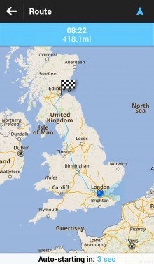
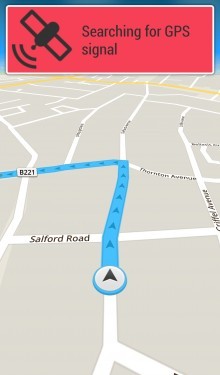
It’s easy to call OpenStreetMap the ‘Wikipedia of maps’, and then be on your way. It’s to-the-point, simple to digest, and sums up its core raison d’être in a heartbeat. But there’s a world of difference between tapping Joe Public’s gargantuan, collective knowledge-base on The Three Stooges or quantum mechanics, and mapping out streets, rivers, buildings and canyons on a collaborative canvas in the cloud.
Indeed, any discussion on the rise of OSM and its credentials in the mapping realm needs to look at how exactly it gets its data, and how reliable this data is.
The inner workings of OpenStreetMap
Today, OpenStreetMap has in the region of 1.5 million registered editors, representing a hockey stick-style growth over the past 18 months. As you can see here, there were only around 650,000 registered users in August 2012.
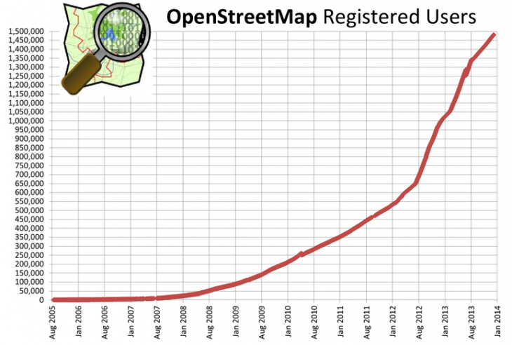
Of course, there are varying degrees of engagement among the editors – just like Wikipedia. “You’ll have a small number of people who sit there editing all day long,” says Coast. “Then you’ll have a much larger group of people editing once a day, once a week or maybe once a month.”
But how does all this data actually get from humans and into the maps? Are they out on the streets with yardsticks and cameras?
“When the project began, then there was nothing at all,” says Coast. “What people did was basically bike around – because biking in Europe is one of the quickest ways to get around. And they’d bike around with a GPS device and a camera, then they would return home with this GPS trace – a series of dots of where you traveled – and then you would match this data to the photos.”
So when things kicked off, it was about as manual a process as you could get. While it still is very much a manual process to some degree, things have evolved over the years to expedite development.
“Now we have access to aerial imagery so you can draw on top of the picture,” says Coast. “That said, some people in some places do still use GPS to map things out, especially if a new road has been built, which isn’t yet included in the aerial imagery.”
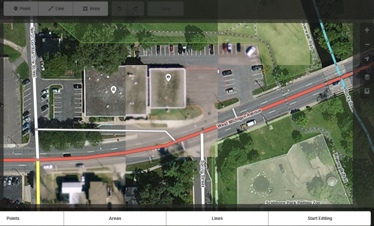
You’re probably thinking, ‘Sure, but where does all the aerial imagery come from? Surely there aren’t 1.5 million people hot-air-ballooning around the globe armed with digital cameras? Well, of course not. The imagery actually arrives via a more sensible conduit. “When I worked at Microsoft, we made a donation of all our aerial imagery to OpenStreetMap, and it’s still updated regularly,” says Coast.
Of course, capturing adequate aerial imagery is a tough task for companies of any size. You have to go on days when there aren’t any clouds, while lighting conditions must also be good. Then you have to prioritize areas that change a lot, or are important to people, such as sprawling conurbations. Typically, such images are garnered from airplanes, but satellite imagery is also used sometimes.
But for OSM’s band of merry editors, how the imagery arrives on the platform doesn’t really matter – all that matters is that they have a good, dependable base upon which to build.
Back in May last year, MapBox launched iD for OpenStreetMap, a slicker editor to encourage more people to contribute to the mapping platform. This was built in pure JavaScript with the d3 visualization library, and was designed to replace a clunkier Flash-based editor – OpenStreetMap adopted this by default just a few months later.
Map features are represented in three ways, using points, lines or areas. Now, points could represent features such as shops, restaurants and monuments, while lines may constitute roads, railway tracks or rivers.
Areas, on the other hand, offer a more detailed way of representing features, and cover boundaries such as surrounding woodland or fields.
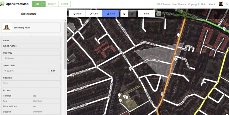
You click the segment of the map you wish to edit, and then enter the vital specifics in the left-hand pane – this could be a building name, street name, driving direction (e.g. ‘one way’) and many other data-points that may be of use to the wider public.
This is the very basics of OpenStreetMap, and for most people familiar with other online editing tools, it shouldn’t take too long to get to grips with.
But from an end-user perspective, vis-à-vis those who ultimately end up using the maps to find their way from A to B, how reliable and extensive is the software? And could someone really be comfortable relying on OSM to not get them lost on the way to the airport?
We take a look.
Making a good map
Google is the big dog with billions of dollars at its disposal and plenty of incentive to ensure Google Maps is in tip-top shape. And OSM is the people-powered underdog, built by unpaid volunteers. There must surely be large swathes of land not covered by OpenStreetMap?
“Actually no, not that a consumer would notice,” says Coast. “As a display map that you would just look at, OpenStreetMap is pretty complete.
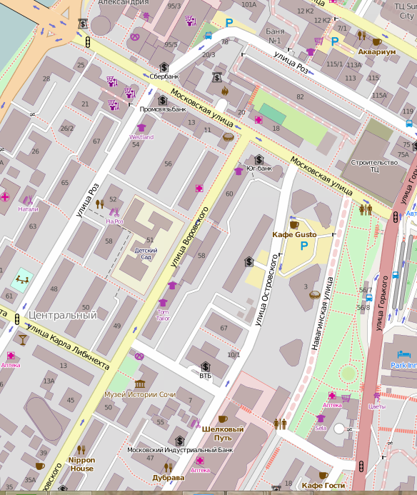
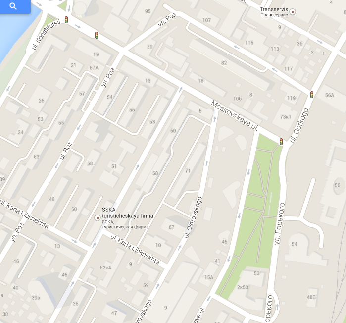
A quick search on the OpenStreetMap Web portal for ‘Sochi’, the location of the 2014 Winter Olympics, reveals that it is pretty complete. And compared with Google Maps, it could be argued it’s actually more extensive.
But what about the darkest corners of Siberia and other such remote locations? “You’d be amazed – places are mapped approximately to the limit, and it would be hard to find anywhere that OSM lacks decent data,” says Coast. “Most of the time it will have either the best, or a very close second for most of the world.”
So if OSM is actually more extensive than Google Maps some of the time, why would any company or consumer use Google Maps over an OpenStreetMap-powered competitor? Well, it seems that it’s not all about the maps and the coverage. The data attached to the maps is every bit as important.
There are basically three core things that go into any good map – there’s the display element (the map itself), and the navigability information within the map (speed-limits, one-way etc) that help you build software for turn-by-turn navigation. And the third piece of the jigsaw is addresses – where are all the houses, and what are the numbers on each house?
“OpenStreetMap is very good at the display part, and it has pretty good navigability information, though it’s not perfect,” says Coast. “But then there’s the address data – this is missing from many parts of OpenStreetMap. You need all three pieces to offer consumer turn-by-turn navigation, and that’s what we’ve been working on at Telenav – filling in those two pieces.”
Like a good wine, online maps improve with age. One of the things that Skobbler, Telenav and others do is gather lots of GPS traces and process it to figure out things for themselves, and this doesn’t require direct user input.
For example, when drivers use these apps while driving along London’s South Circular, GPS data may reveal that most people drive at 60mph along a certain stretch, which means the speed-limit is probably 60mph. Similarly, it can detect if all cars are traversing the same route in the same direction, therefore it’s almost certainly a one-way road.
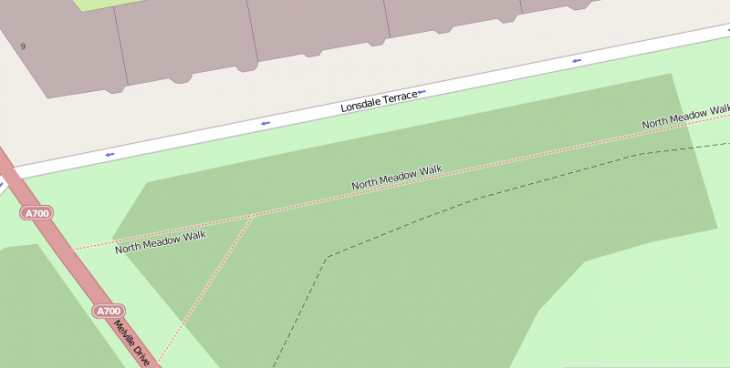
“Without having to send people out or get volunteers, we can process lots of data to figure things out,” says Coast. “And that’s what we do to make OpenStreetMap better for turn-by-turn navigation.”
Postal codes, on the other hand, are a different kettle of fish. Typically constituting a series of letters and/or numbers, these codes ultimately help mail arrive at the right house in the right town. The actual setup, however, varies from country-to-country. In the UK, a full alpha-numeric post code, or ‘postcode unit’, usually matches a handful of addresses (e.g. four houses), or a single, larger end-point such as a warehouse. But matching such data up within OpenStreetMap can be problematic.
The problem lies in not being able to convert a postcode to a latitude/longitude figure, and then back again. The data to easily enable this isn’t freely available in many countries.
“It’s very hard to reverse engineer them, because you can figure out streets just by walking around, you can see names on signs,” says Coast. “But if you’re just walking around trying to figure out what post code it is, that’s more difficult.”
Indeed, another side-project Coast started some years back was called Free The Postcode, the idea being that if you’re sitting in a pub you just ask the guy behind the bar what the postcode is at the pub. And there’s no shortage of pubs, so eventually you can start to complete where all the postcodes are. “You’re never going to get 100% accuracy doing it in such a way,” says Coast. “But you’ll get pretty close.”
In terms of other countries, well, it’s much the same. Each has their own nuances in terms of how much postal code data is available. And this is one of the major stumbling blocks for OSM.
But address data isn’t the only stumbling block.
Attribution: Credit where credit’s due

“We’ve put a lot of time, effort and energy into making this project succeed, and we only ask two things in return,” says Coast. “One of them is if you change the data, please give us the changes back so we can improve the map.”
In other words, if a company taps OSM for its own services and edits the content to make it more accurate, the fundamental premise here is that they should make it available for everyone to benefit from. And what’s the second thing OSM want in return?
“If you use our data, can you please explicitly say, ‘hey, this is Open Street Map’,” continues Coast. “Because that means we’ll get more people using it, more people adding data, and this makes the maps better for everyone.”
However, it seems that people interpret that second clause rather narrowly. “What you see on most (non-OSM) maps is a little copyright of whoever built the map,” adds Coast. “For design reasons, (with OSM) some people want to do away with that line of text on the map – or just make it a tiny little link which then goes to a much broader set of attributions. Our interpretation is you should put ‘Copyright Open Street Map Contributors’ at the bottom right. I don’t think it’s a lot to ask.”
Indeed, in a forum post by OpenStreetMap Foundation Chairman Simon Poole, he cites lack of attribution as a major issue.
“Why is it that getting users of our data to attribute OpenStreetMap correctly seems to be such an uphill battle?,” he says. “This is not something new, browsing the wiki, mailing lists and forums show that this has been an issue from day one. Why is it so difficult for us to get the only compensation we ask for, when at the same time nobody has issues attributing Google?”
To rub salt into the wounds, Poole also says that it’s “not rare” to see a Google attribution on OpenStreetMap-derived content. Ouch. But a quick peek at the OSM Foundation’s licensing terms reveal that they are pretty clear:
“We require that you use the credit “© OpenStreetMap contributors”.
You must also make it clear that the data is available under the Open Database License, and if using our map tiles, that the cartography is licensed as CC BY-SA. You may do this by linking to this copyright page. Alternatively, and as a requirement if you are distributing OSM in a data form, you can name and link directly to the license(s). In media where links are not possible (e.g. printed works), we suggest you direct your readers to openstreetmap.org (perhaps by expanding ‘OpenStreetMap’ to this full address), to opendatacommons.org, and if relevant, to creativecommons.org.”
 What that actually translates to in real terms, it seems, is evidently open to interpretation – in terms of where the attribution actually appears. But it’s supposed to look a little something like this.
How this attribution ends up looking – if there is one at all – will vary from service to service. For example, with Apple – though it doesn’t exclusively use OSM data – you have to dig down quite deep into the acknowledgements to realize that OpenStreetMap data has been used.
You certainly wouldn’t know that it does just from looking at the maps, but then I guess things would start to look pretty ugly if Apple credited every source on the map itself.
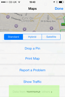
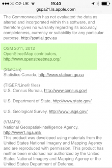
For OpenStreetMap to gain more mindshare among the masses, it maybe does have to begin enforcing the attribution aspect a little more aggressively, or perhaps reword the licensing terms to make them less open to interpretation.
However, there is one other potential avenue open to OpenStreetMap, and that’s to launch its own branded, standalone service.
OpenStreetMap: The brand
Though Wikipedia has an API for third-party developers to tap its data, Wikipedia itself is one of the most recognizable brands on the Web. And that’s because it’s much more than an API for developers – it is a service in its own right.
While the OpenStreetMap website could conceivably be used by a consumer for some navigational purposes, it hasn’t been designed as such. So even as more third-party services and developers turn to OpenStreetMap, it wouldn’t likely receive the recognition it perhaps deserves – it’s a back-end, not a front-end, after all. So would there ever be scope to push-out an OpenStreetMap-branded service on its own?
“If it was up to me, then we would certainly be a lot more consumer focused, and make the website usable like that,” says Coast. “There are some trade-offs by just focusing on the developer side of things rather than users. It basically makes our costs a lot lower, and it makes the organization more lean and focused too. But it’ll probably stay the way it is for the foreseeable future.”
So it seems despite the massive branding boost it could receive by going out on its own, there would be massive cost implications. You know those ‘give us money’ banners you see at the top of Wikipedia, with Jimmy Wales’ head plastered across the top? Yup, you’d perhaps have to endure such hijinks on OpenStreetMap too.
Speaking of which… how exactly is OpenStreetMap funded?
A lean mapping machine
As we’ve noted already, OpenStreetMap has no paid employees, no premises, and no real overheads to speak of. It’s truly a people-powered machine. But there has to be at least some costs, right?
Though Coast didn’t have an exact figure to hand, he did put its annual donations in the “low tens of thousands” bracket. “It’s practically nothing,” he says. “It’s low, because our costs are low.”
Indeed, London’s UCL and Imperial College both give “free or very cheap” hosting for OSM’s servers. And the donations it does receive fluctuate in line with very specific needs. If they do require a new database server, for instance, they run a specific funding drive to garner whatever funds are necessary to attain it.
So there’s no interest in doing a Wikipedia-style banner ad for donations? “Their infrastructure costs are a lot higher,” says Coast. “But some people have said we should do something similar.”
If OpenStreetMap can get by just fine without gazillions in the coffers, why change that, right?
Efficiency, not ideology
While he does agree with many facets of the ideological arguments contained within Serge Wroclawski’s Why the World Needs OpenStreetMap post, Coast is more concerned about the lack-of-efficiency aspect of having too many online mapping platforms.
“The sheer efficiency angle is a bigger point and slightly more important to me,” he says. “Depending on how you count, there are four major (online) maps of the world. Or, I should say, four relatively-complete maps of the world. I mean, do we really need four different maps, or would it be easier if we had one that was open?”
The four Coast refers to, of course, are Google, Tom Tom, HERE, and OpenStreetMap. Though if you want to drill down into localized regions then there is a whole lot more, such as Ordnance Survey in the UK. And this is a key point to pick up on – having an open, editable online mapping platform has different benefits depending on where you are in the world.
“The reason I started in the UK is because we have the Ordnance Survey, which makes these great maps, but then to use them you have to pay money,” explains Coast. “But then if you’re somewhere where there aren’t very good maps, like large parts of Africa, then there’s a different reason for making this data open. If you’re in a relief area, like we had with Haiti after the earthquake, there’s a whole different set of reasons why you’d want an open map that anyone can contribute to quickly.”
Over and above all this, however, OpenStreetMap-powered platforms such as those belonging to Skobbler, are able to offer 100% offline access to the maps. So, someone may well use Google Maps in their home country if they’re on an unlimited data plan, but then switch to something like GPS Navigation & Maps when abroad. All that’s required is the (free) GPS function of a smartphone, and the pre-installed map of the destination country.
For the privacy-concerned among you, this also means you can navigate without giving your personal location details away.
The future of OpenStreetMap
Though there are many things to celebrate about OpenStreetMap, such as noble intentions and scalability, there’s no escaping some of the inherent drawbacks. You would be hard-pushed to find an OpenStreetMap-powered mobile app that’s quite as slick as Google Maps – and that’s not the gushing-praise of a ‘Google Fanboy’ talkin’.
And with Google Maps, you get a lot more than simply maps and navigation. In addition to its own crowdsourced efforts via Map Maker, Waze, and its newly launched Maps Gallery, there’s the tight integration with Google Earth and Street View, something that OpenStreetMap will have a difficult time emulating.
But could OSM’s scope be expanded to include Street View-esque features?
“There’s a whole bunch of very interesting problems with that,” says Coast. “When you look at doing very high quality street imagery, it’s very expensive to do. All those vehicles and fuel, and secondary costs such as cameras and somewhere to store those hi-res photos on the vehicle. Then there’s all the processing facilities. You can see how hard and expensive it is to do.”
Fair enough, point taken.
But with the increasing affordability of professional-grade equipment and sophisticated gadgetry, where are we likely to see OpenStreetMap go from here?
We’ve seen some amazing use-cases for drones in recent times. A filmmaker used one to capture amazing scenes of New York, while the media enlisted them to document political protests in Bangkok last month. And let’s not forget this gnarly surfing video shot with a drone and a GoPro at Banzai Pipeline. So is this something OSM editors could use to their advantage?
“It’s very nascent, but there are now kits that let you take lots of photos of a specific area and turn it into a geo-rectified picture,” says Coast. “There’s one thing you have to note though – whether it’s a satellite, a plane or a drone – it’s taking a picture, but it’s probably not quite directly ‘down’. And then the Earth is not flat – there’s hills, there’s valleys. And you have to take all this into account when you stitch all the photos together.”
Indeed, there are many distortions that can come into play when taking photos from above, including the quality of the air and the atmosphere. Drones may offer some potential for amateur cartographers, but it opens up a whole hornet’s nest of issues too.
A more immediate and realistic development at OpenStreetMap towers is likely to center around one simple thing – growth. As with many online projects, things tend to snowball the more people start using it, and there has been a lot of snowballing going on in recent times. This looks set to continue.
“I think more and more people will start using it,” says Coast. “In the beginning it was very much a chicken-and-egg problem, right? You start with nothing, you do a little bit of data, but then you don’t have enough data to attract people. More people will put more data in if there was already more data, so it took a while to bootstrap the project to where it is now. But now it’s a very viable competitor to commercial offerings.”
With Telenav and Skobbler now pooling their collective resources, working to iterate and improve OpenStreetMap, and guided by the very man who started it all off ten years ago, it will be interesting to see where things go in the months and years that follow.
Image Credit 1 – Shutterstock | Image Credit 2 – Shutterstock | Image Credit 3 – Shutterstock
Get the TNW newsletter
Get the most important tech news in your inbox each week.

