Google Maps has recently added a number of cycling features as more people have taken to riding bikes, ebikes, and electric scooters during the coronavirus pandemic. And yet as much as I appreciate some of these updates, as I’ve started to explore other cycling-oriented applications, Google Maps‘ limitations have become increasingly obvious.
Here are just a few changes that I believe could make Google Maps far more appealing to cyclists.
Let me plan and save routes ahead of time
I get it, Google Maps is mostly aimed at commuters and people taking the occasional impromptu trip. It’s meant to get you from point A to B as efficiently as possible, to the best of the app’s knowledge.
But sometimes I don’t want to just get somewhere as fast as possible. Sometimes I want to take the scenic route. Sometimes I want to go up unnecessary hills for a workout. Other times I want the opposite — to minimize sweating as much as possible.
Yes, there are other apps that are meant to do this — my app of choice is Komoot — and you can plan routes in Google Maps using roundabout methods. But Google Maps is often the most convenient, and unfortunately, the best you can really do with the mobile version of Google Maps app is add multiple stops and view your past routes.
Allowing users to plan their route in advance would not only provide more flexibility, but also help users feel safer by being more confident in their route decisions. It also means you could save your favorite workout routes easily — and it’s not hard to see how Google could integrate such functionality with Google Fit.
Heat maps
Even if I am just trying to get from point A to point B, the best cycling routes don’t always follow car traffic patterns or use bike lanes. In my own neighborhood, I know to avoid certain streets with shoddy bike paths. Sometimes I’d much rather go down a quiet, wide residential street without a bike line than a busy road with an unprotected bike lane that leaves me just a foot or two from angry drivers.
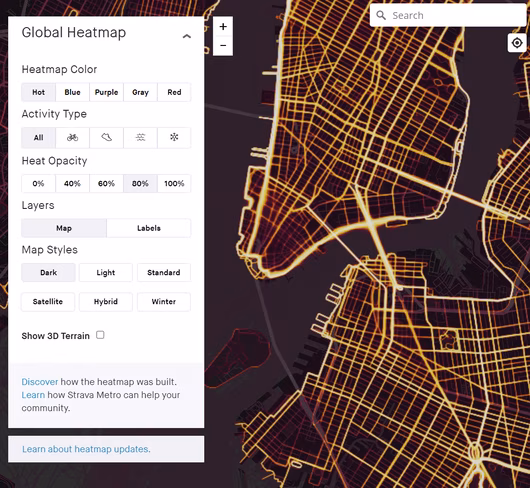
Though I’m sure Google factors in common user routes to some degree, I’d love some kind of heat map feature that allowed me to see what paths cyclists are normally taking — and where they deviate from Maps’ suggestions. This is especially useful when I’m visiting a new cycling location where I’m not familiar with the best paths to take.
This is one of the best features in Strava and Google no doubt has the data it needs to offer similar functionality.
Terrain and path information
There’s a common theme here, and it’s that Google gives riders very little information or choice in how their rides actually play out. Aside from simply choosing where I want to go with my bike, I don’t know what type of path I’m taking throughout the route. Am I going to be on a fully protected bike lane, or will I be on a narrow painted lane bumping elbows with drivers? Will I have to ride on a dirt trail or will I be on paved roads?
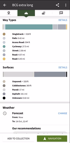
This is information Google likely already has and which could make an immense difference for cyclists. Different riders — and even different bikes — are better suited to different terrains, and being able to plan my route with a better understanding of the roads to come can be a literal lifesaver.
Smarter multimodal commutes
Back in 2019, Google announced support for mixed-mode commutes, allowing you to combine cycling with other methods of transportation. But since then, I’m not sure I’ve seen any suggestions of the sort, despite living in NYC. You know, one of the biggest cities in the world.
That’s a shame. Sometimes it’s fastest to combine a train ride with a short bike or scooter trip, avoiding long and dreary transfers. It’s not just for regular bikes either. Folding bikes and e-scooters are easy to bring on a train or cab or your own car, and could benefit immensely from multimodal options during longer trips.
And these are just a few improvements that the company could likely implement without making Maps too bloated. Heck, I’d even pay for a separate app using Google Maps data and Assistant integration just to get some proper cycling-centric navigation. If Google’s always going to be collecting data on us, they might as well put it to good use.
Get the TNW newsletter
Get the most important tech news in your inbox each week.