Google Maps on the desktop has been updated with a new feature that lets you work out the distance between multiple places by plotting your route on the map.
To use the option, you just need to right click anywhere on a map and select ‘Measure Distance’ and then select a destination to see the distance between two points. Additional stops, turns or destinations can be calculated with additional clicks. You can also drag any of your dropped route lines if you want to tweak them a bit or if you want to make them align with actual roads for more accurate route measurement, for example.
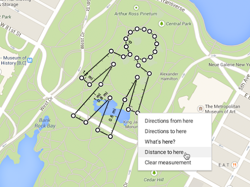
The feature had previously been available under the experimental Google Labs options but is now available as part of the main service. Although generally useful for anyone planning a roadtrip, it also means you can now use Google Maps to plan a new morning run or cycle ride by distance, or draw a little man over a park, should you wish.
➤ Google Maps [Google +]
Featured Image Credit – PEDRO LADEIRA/AFP/Getty Images
Get the TNW newsletter
Get the most important tech news in your inbox each week.