The chances are if you’re reading this you’ve at least used Google Maps before, and the odds are you’ve also used Street View to get a feel for a place before you visit. But Street View only really gives you the surface image…it doesn’t really let you see a landmark up close in all its glory.
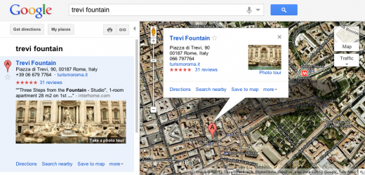
Today though, Google is rolling out photo tours, a new Google Maps feature that guides you through a scene with 3D photos. The tours are available for more than 15,000 sites around the world, covering the likes of Trevi Fountain in Italy and ‘Half Dome’ in Yosemite.

It’s worth noting that your computer and browser will need to meet the system performance requirements for MapsGL, which uses technology called WebGL (Web-based Graphics Library) to enhance Google Maps.
The photo tours can be kicked into action from within Google Maps in two ways. One way is when you search for a place, the results in the left panel will indicate if there is a photo tour available: click the thumbnail image or the link to launch the tour. Alternatively, you can click on the label for a landmark if you’re browsing the map which will tell you if a tour is available.
Unlike Street View which uses images captured by its own dedicated fleet of vehicles, the photo tours tap the public’s snaps to create the tours – from Picasa and Panoramio. “We start by finding clusters of overlapping photos around major landmarks,” explains Steve Seitz, a Software Engineer at Google. “From the photos, our system derives the 3D shape of each landmark and computes the location and orientation of each photo. Google Maps then selects a path through the best images, and adds 3D transitions to seamlessly guide you from photo to photo as if you’re literally flying around the landmark and viewing it from different perspectives.”
Google says that every photo will be attributed to its contributor, adding that the more photos people share, the better the tours will become. You will of course have to make your images public if they’re to stand a chance of being included, though Google doesn’t stipulate whether it will still seek permission to use images even if they are public.
Meanwhile, you can see a map of all the available tours here, or watch Google’s new photo tours promo video below:
Get the TNW newsletter
Get the most important tech news in your inbox each week.


