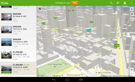
Google has today launched v2 of its Google Maps API, bringing along better support for maps on tablets, integration with Google Play services, new information layers and more. The new API is available now for developers to start playing and using maps that are more on par with Google Maps for Android’s capabilities.
The new API has been integrated with Google Play services 2.0, the platform that Google launched to help developers roll out updates to Google products more quickly. This enables features like the display of Photo Spheres and new data layers to be integrated more quickly.
The new API is available for any devices from Android Froyo and up. Google points to three major new features in the new API:
- More dynamic and flexible UI designs for large screen Android devices, such as tablets.
- Adding more Google Maps layers in their apps including satellite, hybrid, terrain, traffic and now indoor maps for many major airports and shopping centers.
- The ability to create markers and info windows with less code.
The focus on tablets makes a lot of sense, as this is still a very weak spot in the Android app ecosystem at large, and Google has been taking steps to correct that. This includes better templates for Android developers making tablet apps, a genuine focus on creating specific tablet layouts for apps and more. The addition of tablet-friendly UI elements to the Maps API can’t hurt.
More layers and an easier way to display fragments of maps inside other apps are also features of version 2.0.
The new API leverages vector-based maps with both 2D and 3D views, allowing for tilting and rotating of the maps. This is something that Google Maps for Android did previously, but Google had not offered via the API.

Version 2.0 of the API also includes the ability to display and manipulate Photo Spheres, the images captured by a special camera mode in Android 4.2. Since Photo Spheres’ are captured in JPG, with open XMP metadata, they can be tweaked or added at will via the API. Google says that you can even create Photo Spheres from normal panoramic images by adding this data.
Image Credit:Justin Sullivan/Getty Images News
Get the TNW newsletter
Get the most important tech news in your inbox each week.


